Waconia XC Homecoming “FUN” Run 2026
“Turn by Turn” Directions
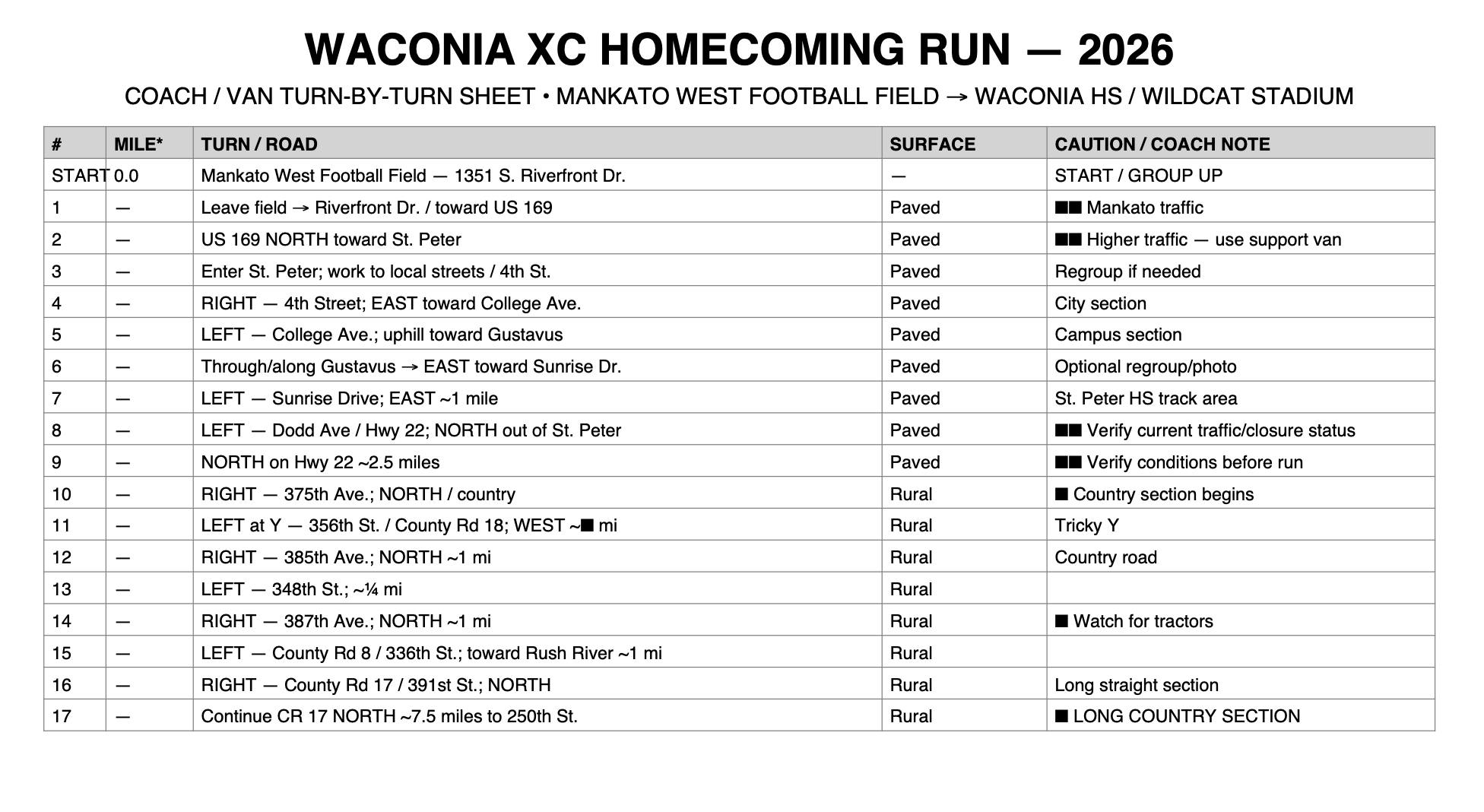
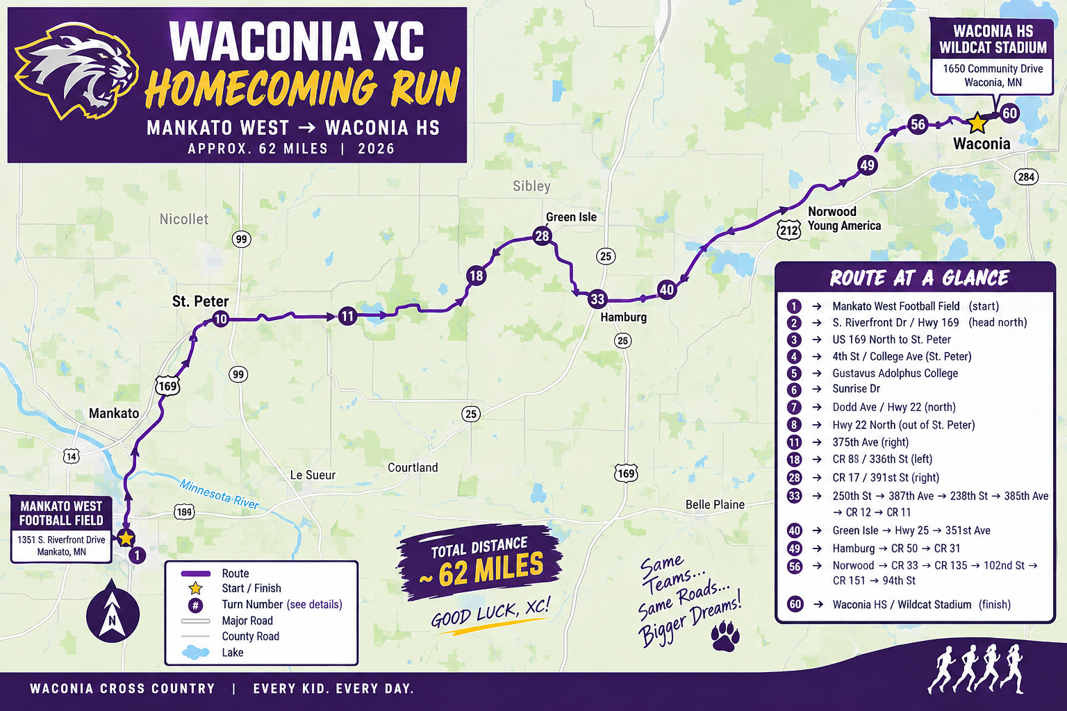
Mankato West → Waconia HS / Wildcat Stadium
Target distance: approximately 62–65 miles.
PART I — MANKATO WEST → ST. PETER
1. START — Mankato West High Schoool
1351 S Riverfront Dr
Mankato, MN 56001
2. Leave the football complex and head toward S. Riverfront Drive / Hwy 169.
⚠️ BUSY — Mankato/North Mankato traffic.
3. Take US 169 NORTH toward St. Peter.
NOTE: Hwy 22 between Kato and St. Peter is under construction…we will seek out if it is passable by runners/bike as to NOT be on Hwy 169! (this will be a “game day” decision!!
4. Enter St. Peter and get onto the local street network.
5. Work toward 4th Street / College Avenue.
6. Take College Avenue toward Gustavus Adolphus College.
7. Run through/along the Gustavus campus toward Sunrise Drive.
8. Take Sunrise Drive east.
9. At Dodd Avenue / Hwy 22, turn north.
10. Take Hwy 22 NORTH out of St. Peter.
⚠️ The Mankato–St. Peter closure does not mean the northern portion of Hwy 22 should automatically be treated as closed; verify conditions immediately before the run.
PART II — THE COUNTRY BEGINS 🌾
Approximately Mile 15
11. RIGHT — 375th Avenue
🌾 COUNTRY ROAD
Run approximately 4 miles.
This is the point where the run really becomes the Waconia XC Homecoming Run.
12. At the Y — LEFT / WEST — 356th Street / County Road 18
Run approximately ⅓ mile.
13. RIGHT / NORTH — 385th Avenue
Run approximately 1 mile.
14. LEFT — 348th Street
Run approximately ¼ mile.
15. RIGHT — 387th Avenue
Run approximately 1 mile NORTH.
🚜 TRACTOR COUNTRY.
16. LEFT — County Road 8 / 336th Street
Head toward Rush River.
17. RIGHT — County Road 17 / 391st Street
Now you've got one of the big stretches.
Approximately Mile 25
18. Stay on County Road 17 NORTH for approximately 7½ miles.
PART III — THE MIDDLE OF NOWHERE
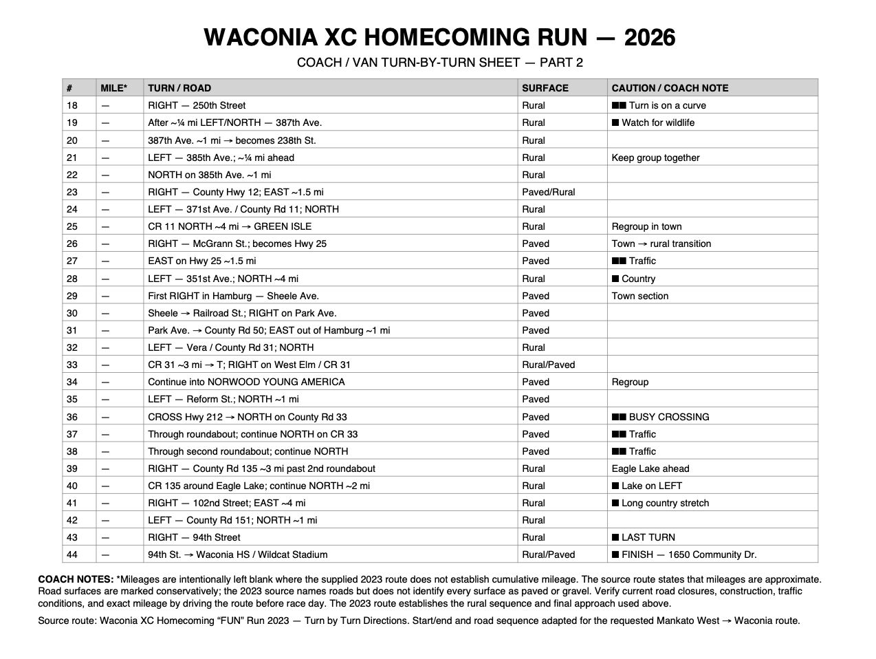
19. RIGHT — 250th Street
⚠️ TURN IS ON A CURVE.
20. After approximately ¼ mile — LEFT/NORTH — 387th Avenue
And yes…
🦨 WATCH FOR SKUNKS.
21. Stay on 387th Avenue approximately 1 mile.
22. 387th turns RIGHT and becomes 238th Street.
23. After approximately ¼ mile — LEFT — 385th Avenue
24. NORTH on 385th Avenue approximately 1 mile.
25. RIGHT — County Highway 12
26. EAST on County 12 approximately 1½ miles.
27. LEFT — 371st Avenue / County Road 11
Now head north for approximately 4 miles.
28. Continue on County Road 11 into GREEN ISLE.
PART IV — GREEN ISLE → HAMBURG
29. In Green Isle — RIGHT on McGrann Street
McGrann becomes Hwy 25.
30. EAST on Hwy 25.
Approximately 1½ miles.
⚠️ PAY ATTENTION TO TRAFFIC.
31. LEFT — 351st Avenue
32. NORTH on 351st Avenue approximately 4 miles.
HAMBURG
33. First RIGHT in Hamburg — Sheele Avenue
34. Sheele becomes Railroad Street.
35. RIGHT — Park Avenue
36. Park Avenue becomes County Road 50.
37. EAST out of Hamburg approximately 1 mile.
38. LEFT — Vera / County Road 31
39. NORTH on County Road 31.
PART V — HAMBURG → NORWOOD YOUNG AMERICA
40. Stay on County Road 31 approximately 3 miles.
41. At the T — RIGHT — West Elm / County Road 31
42. Continue into downtown NORWOOD YOUNG AMERICA.
43. LEFT — Reform Street
44. NORTH approximately 1 mile to Hwy 212.
⚠️ MAJOR CROSSING — HWY 212
45. CROSS Hwy 212 and continue NORTH on County Road 33.
Kwik Trip should be on your right.
46. Continue through the first roundabout.
47. Continue NORTH on County Road 33.
48. Continue through the second roundabout.
49. Approximately 3 miles after the second roundabout — RIGHT — County Road 135.
PART VI — THE FINAL COUNTRY MILES 🌾
50. County Road 135 — continue around Eagle Lake.
🎣 Eagle Lake will be on your LEFT.
51. Continue north on CR 135 approximately 2 miles.
52. RIGHT — 102nd Street
53. EAST on 102nd Street approximately 4 miles.
This is another excellent long rural stretch.
54. LEFT — County Road 151
55. NORTH approximately 1 mile.
56. RIGHT — 94th Street
🔥 LAST TURN!
🏁 FINAL MILES — WACONIA
57. EAST on 94th Street.
58. Continue toward Waconia.
59. Follow the final approach into the Waconia school/athletic complex.
60. FINISH — WILDCAT STADIUM
Waconia High School
1650 Community Drive
Waconia, MN 55387.